- Home
- Quintessential Queensland
- Distinctiveness
- Perceptions
- Perceptions: how people understand the landscape
- From runs to closer settlement
- Geological survey of Queensland
- Mapping a new colony, 1860-80
- Mapping the Torres Strait: from TI to Magani Malu and Zenadh Kes
- Order in Paradise: a colonial gold field
- Queensland atlas, 1865
- Queensland mapping since 1900
- Queensland: the slogan state
- Rainforests of North Queensland
- Walkabout
- Queenslanders
- Queenslanders: people in the landscape
- Aboriginal heroes: episodes in the colonial landscape
- Australian South Sea Islanders
- Cane fields and solidarity in the multiethnic north
- Chinatowns
- Colonial immigration to Queensland
- Greek Cafés in the landscape of Queensland
- Hispanics and human rights in Queensland’s public spaces
- Italians in north Queensland
- Lebanese in rural Queensland
- Queensland clothing
- Queensland for ‘the best kind of population, primary producers’
- Too remote, too primitive and too expensive: Scandinavian settlers in colonial Queensland
- Distance
- Movement
- Movement: how people move through the landscape
- Air travel in Queensland
- Bicycling through Brisbane, 1896
- Cobb & Co
- Journey to Hayman Island, 1938
- Law and story-strings
- Mobile kids: children’s explorations of Cherbourg
- Movable heritage of North Queensland
- Passages to India: military linkages with Queensland
- The Queen in Queensland, 1954
- Transient Chinese in colonial Queensland
- Travelling times by rail
- Pathways
- Pathways: how things move through the landscape and where they are made
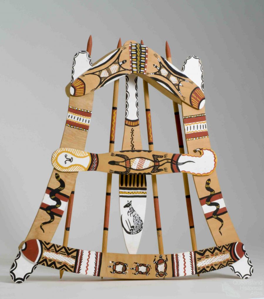
- Aboriginal dreaming paths and trading ways
- Chinese traders in the nineteenth century
- Introducing the cane toad
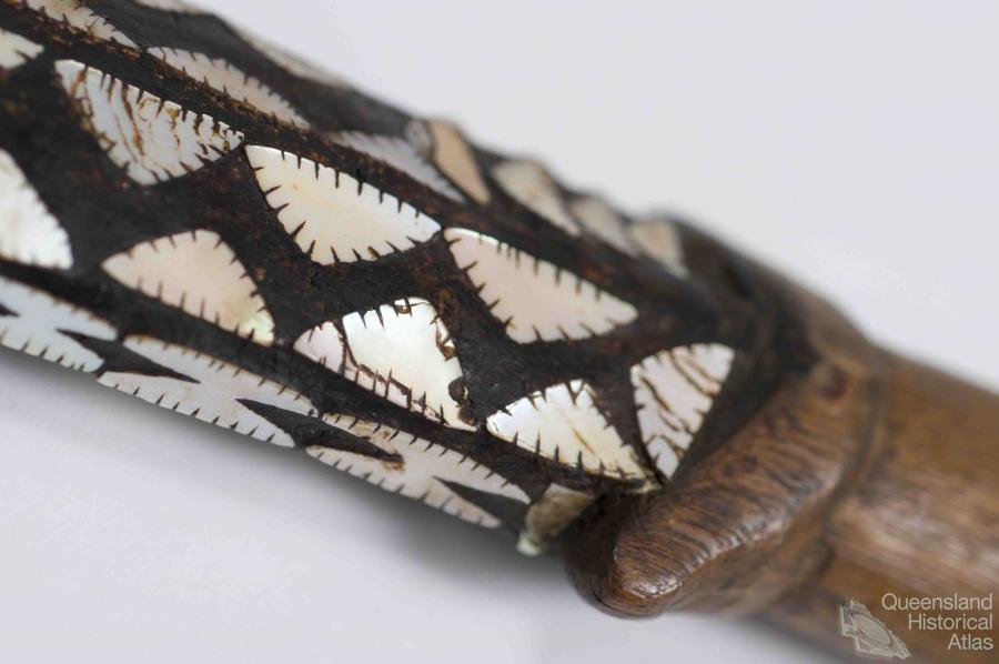
- Pituri bag
- Press and the media
- Radio in Queensland
- Red Cross Society and World War I in Queensland
- The telephone in Queensland
- Where did the trams go?
- ‘A little bit of love for me and a murder for my old man’: the Queensland Bush Book Club
- Movement
- Division
- Separation
- Separation: divisions in the landscape
- Asylums in the landscape
- Brisbane River
- Changing landscape of radicalism
- Civil government boundaries
- Convict Brisbane
- Dividing Queensland - Pauline Hanson’s One Nation Party
- High water mark: the shifting electoral landscape 2001-12
- Hospitals in the landscape
- Indigenous health
- Palm Island
- Secession movements
- Separate spheres: gender and dress codes
- Separating land, separating culture
- Stone walls do a prison make: law on the landscape
- The 1967 Referendum – the State comes together?
- Utopian communities
- Whiteness in the tropics
- Conflict
- Conflict: how people contest the landscape
- A tale of two elections – One Nation and political protest
- Battle of Brisbane – Australian masculinity under threat
- Dangerous spaces - youth politics in Brisbane, 1960s-70s
- Fortress Queensland 1942-45
- Grassy hills: colonial defence and coastal forts
- Great Shearers’ Strike of 1891
- Iwasaki project
- Johannes Bjelke-Petersen: straddling a barbed wire fence
- Mount Etna: Queensland's longest environmental conflict
- Native Police
- Skyrail Cairns (Research notes)
- Staunch but conservative – the trade union movement in Rockhampton
- The Chinese question
- Thomas Wentworth Wills and Cullin-la-ringo Station
- Separation
- Dreaming
- Imagination
- Imagination: how people have imagined Queensland
- Brisbane River and Moreton Bay: Thomas Welsby
- Changing views of the Glasshouse Mountains
- Imagining Queensland in film and television production
- Jacaranda
- Literary mapping of Brisbane in the 1990s
- Looking at Mount Coot-tha
- Mapping the Macqueen farm
- Mapping the mythic: Hugh Sawrey's ‘outback’
- People’s Republic of Woodford
- Poinsettia city: Brisbane’s flower
- The Pineapple Girl
- The writers of Tamborine Mountain
- Vance and Nettie Palmer
- Memory
- Memory: how people remember the landscape
- Anna Wickham: the memory of a moment
- Berajondo and Mill Point: remembering place and landscape
- Cemeteries in the landscape
- Landscapes of memory: Tjapukai Dance Theatre and Laura Festival
- Monuments and memory: T.J. Byrnes and T.J. Ryan
- Out where the dead towns lie
- Queensland in miniature: the Brisbane Exhibition
- Roadside ++++ memorials
- Shipwrecks as graves
- The Dame in the tropics: Nellie Melba
- Tinnenburra
- Vanished heritage
- War memorials
- Curiosity
- Curiosity: knowledge through the landscape
- A playground for science: Great Barrier Reef
- Duboisia hopwoodii: a colonial curiosity
- Great Artesian Basin: water from deeper down
- In search of Landsborough
- James Cook’s hundred days in Queensland
- Mutual curiosity – Aboriginal people and explorers
- Queensland Acclimatisation Society
- Queensland’s own sea monster: a curious tale of loss and regret
- St Lucia: degrees of landscape
- Townsville’s Mount St John Zoo
- Imagination
- Development
- Exploitation
- Transformation
- Transformation: how the landscape has changed and been modified
- Cultivation
- Empire and agribusiness: the Australian Mercantile Land and Finance Company
- Gold
- Kill, cure, or strangle: Atherton Tablelands
- National parks in Queensland
- Pastoralism 1860s–1915
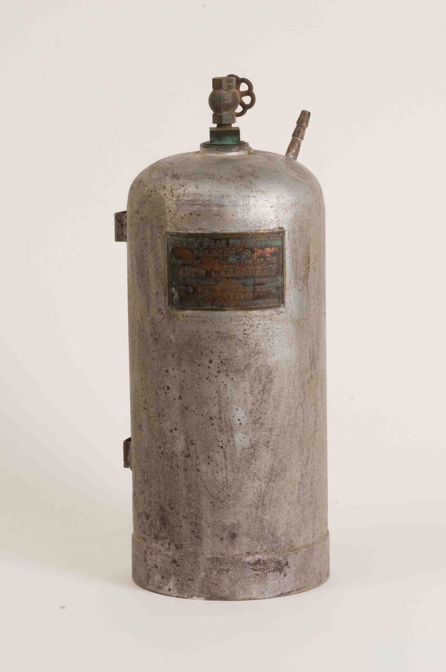
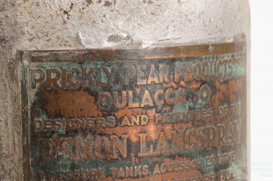
- Prickly pear
- Repurchasing estates: the transformation of Durundur
- Soil
- Sugar
- Sunshine Coast
- The Brigalow
- Walter Reid Cultural Centre, Rockhampton: back again
- Survival
- Survival: how the landscape impacts on people
- Brisbane floods: 1893 to the summer of sorrow
- City of the Damned: how the media embraced the Brisbane floods
- Depression era
- Did Clem Jones save Brisbane from flood?
- Droughts and floods and rail
- Missions and reserves
- Queensland British Food Corporation
- Rockhampton’s great flood of 1918
- Station homesteads
- Tropical cyclones
- Wreck of the Quetta
- Pleasure
- Pleasure: how people enjoy the landscape
- Bushwalking in Queensland
- Cherbourg that’s my home: celebrating landscape through song
- Creating rural attractions
- Festivals
- Queer pleasure: masculinity, male homosexuality and public space
- Railway refreshment rooms
- Regional cinema
- Schoolies week: a festival of misrule
- The sporting landscape
- Visiting the Great Barrier Reef
By:
Clive McAlpine A flight to Charleville
I love peering down through the small curved window of planes as they land and ascend into Brisbane. I notice the other passengers also point out landmarks with happiness as they arrive back home from a trip overseas. The deep blue waters and sandbars of Moreton Bay and the sprawling suburbs of Sandgate and Redcliffe span out below. The tiny specs of the early morning traffic snake their way over the Hornibrook Bridge. The North Pine River winds its way through the mangroves to Moreton Bay, bordered by small patches of bushland which stand as sentinel to the pre-European landscape. In the 150 years since Queensland broke away from New South Wales, and after a slow beginning as largely an agricultural export economy, Queensland has become an economically and culturally diverse and prosperous society. The sign to the Brisbane Airport displays Queensland’s population counter as 4,455,149, increasing at one person every 4 minutes 33 seconds. Growth is rapid in the Great South East. The mood of growth and rapid urbanisation has replaced the once sleepy southeast, transforming it into sprawling suburbs and motorways, city bypasses and tunnels, linking north and south, east and west. Our politicians proudly claim ‘we are now entering a new phase of development’ – more transformation.
Transformation, degradation and rejuvenation are part of the cycle of environmental change, and are observable in all Queensland landscapes. The aerial perspective is a powerful tool for understanding landscapes and how they have changed. I reflect on the Queensland landscape as I sit on the Qantas QLink flight turbo-propeller plane. We are travelling to Charleville, where we are doing research on the effect of drought on koalas. We are now flying over Dayboro, and my thoughts are saddened as I recognise the signs of transformation. The native wattles, brush box, spotted gums and ironbarks which once dominated the land are now contained in fragmented patches. They have been replaced by slash pines, camphor laurel and Chinese elm, the curse of bushcare and conservation groups, invading remnant bushland and creeks, creating novel ecosystems with a mix of native and exotic species. The paddocks that were once dairy farms supplying butter to mother England are now five and ten acre blocks with spreading homes and horse stables. The rectangular, red-brown earth patches of the pineapple farms stand out on the hill sides. The landscape is changing with the people and the economy – the dairy farmers have gone, replaced by city dwellers who are seeking open space and tranquillity with their country block.
Silhouetting behind Dayboro are the numerous hills and gullies of the D’Aguilar Range. Although not as majestic as Sydney’s Blue Mountains, the hardwood eucalypt and rainforests and waterholes are now protected as conservation areas, an outcome of the South East Queensland Forests Agreement. The tall straight trunks of the spotted gum, ironbark and blackbutt forests give a deceptive sense of ‘naturalness’, having avoided the alienating transformation characteristic of the sprawling suburbs of Brisbane and the Dayboro dairy farms. However, these hardwood forests and many others along the coastal ranges from Cairns to the New South Wales border provided the timber framing, weatherboards, pylons, girders, and railway sleepers that built Queensland houses, bridges, jetties and railways. Most of the native cedar, hoop and kauri pine had been logged out within the first 50 years. Over a century of logging by the early timber cutters and the foresters who followed has transformed the old-growth forests into forests dominated by young and mature trees. In the absence of a major wildfire in a projected hotter and drier climate, it will take at least another 50 years for these forests to become old-growth and provide nest-hollows for the majestic yellow-bellied and greater gliders, that have glided through these trees for hundreds of thousands of years.
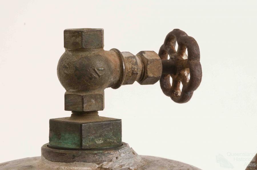
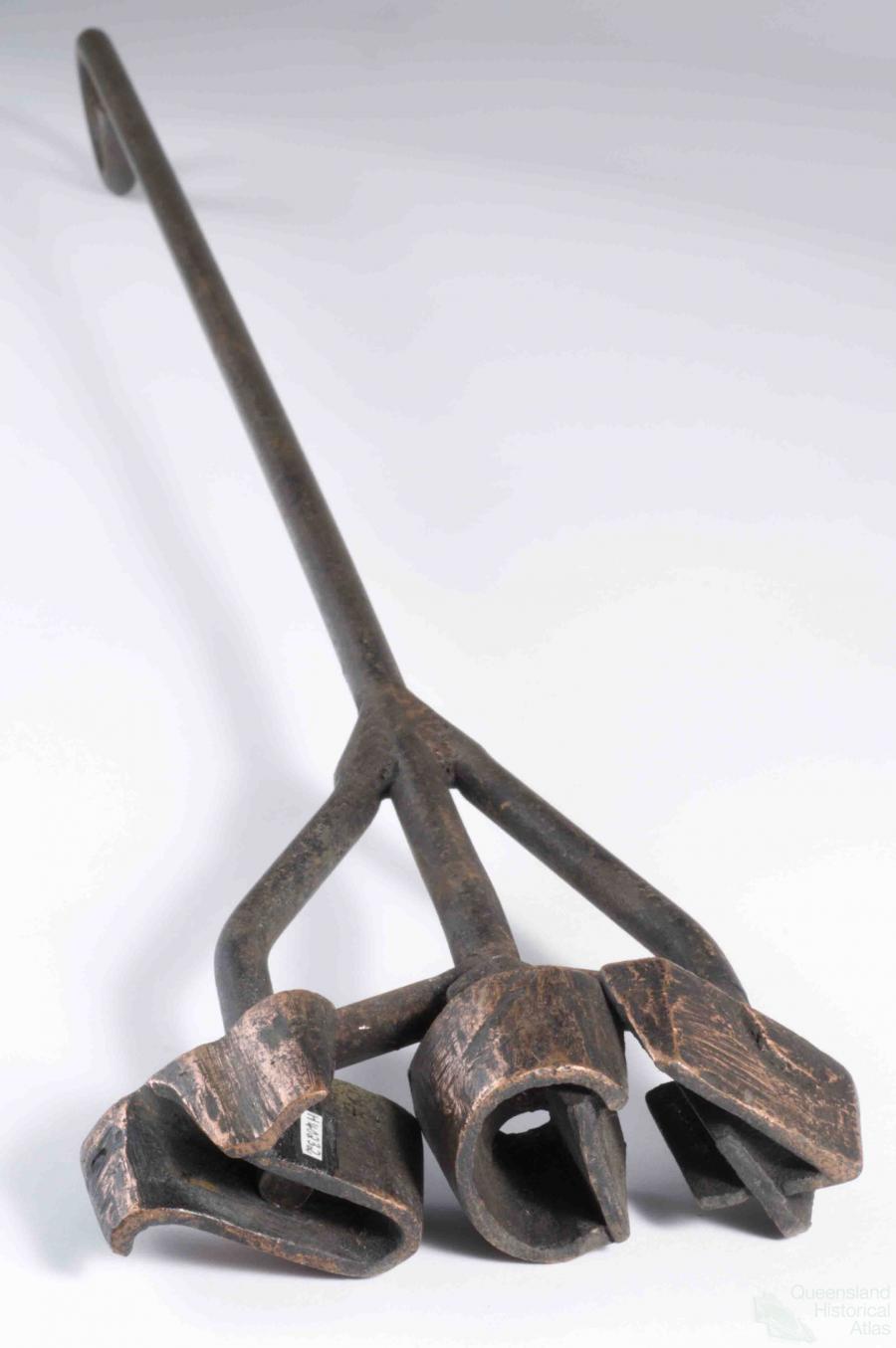
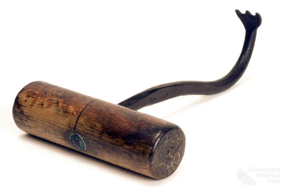
The transformation of tree-dominated landscapes to grass-dominated grazing landscapes characterises much of Queensland’s early and recent environmental history. Beyond the D’Aguilar Range, the Brisbane Valley stretches out below. This is still mostly cattle country, with peri-urban ‘blockies’ encroaching on the margins. Like the Burnett, Fitzroy and Burdekin river basins, the dry eucalypt forests and woodlands of the Brisbane Valley were transformed early in Queensland’s history into productive cattle pastures, which became dominated by black speargrass. Favoured by fire, this native grass rapidly increased in abundance, forming the east-west divide between cattle and sheep in Queensland. The barbed seeds become embedded in the wool and skin of sheep devaluing the wool and killing the animals. Ringbarking (the practice of manually cutting deep circles in the lower tree trunk to stopping the flow of sap from the roots to the branches) was widely practised (often using teams of low-paid Asian workers) among early settlers to reduce the competition effect of trees on pasture production. As early as the 12 November 1872, classified advertisements were placed in The Brisbane Courier for the sale of land with ‘substantial three rail fence, trees ring barked, and cleared of light timber.’
We are now approaching Roma in the small Qantas plane. Below is the Brigalow Belt, where dark strips of remnant brigalow border paddocks of wheat and buffel grass. The battle to control the prickly pear and post-war transformation of the brigalow was seen as a triumph of man and machine over nature. From the 1960s through to 2000, regions such as central Queensland were cleared at a rate of 1% per year. Transformation was rapid and in many areas permanent. However, brigalow like the mulga, gidgee and many eucalypt ecosystems of Queensland, has the capacity to regenerate naturally, often forming dense stands of regrowth. Since 1990s, land clearing became politically controversial and was a major issue in the 2004 election. Land clearing peaked in 1999-2000 at 758,000 ha. In 2004, the Queensland Native Vegetation Management Act was legislated to phase out clearing of remnant vegetation. Clearing of most regrowth is still permitted, except in the catchments of the Great Barrier Reef.
We make a short stop at Roma, before heading on to Charleville and the red-earthed landscapes of the Mulgalands. For thousands of years, drought, flood and fire have shaped the mulga landscapes, keeping them with the natural bounds of variability. Over the past 150 years, however, European land-use has transformed the landscape into a mosaic of grazing paddocks and modified native vegetation. From the air, a mosaic of ‘pulled’ and regenerating mulga spreads out across the dry red earth. From the ground, a degraded patchy mosaic of wire grass, mulga and bare earth are a legacy of recent and more distant droughts and overgrazing. Much of the damage was done by the big mobs of sheep that spread out over the floodplains of the Warrego, Paroo, Bullo and associated creek systems in the late 1800s. For the first 40 years of pastoral settlement, the region boomed. Then came the Federation drought and the sheep population crashed, causing extensive degradation of the river frontage country. In a detailed report written in 1910, Stock Inspector Wyatt, in referring to Nebine Creek, wrote ‘the flats have originally carried Mitchell, bluegrass ... the best grasses, cotton and saltbush, have been almost destroyed by drought, heavy stocking and rabbits’.
The discovery of artesian water opened up the red-earth mulga country away from the creeks and rivers. During a succession of droughts, mulga was cut to feed the mobs of sheep. Cattle are now preferred to sheep with goats becoming a lucrative sideline. Mulga is still being pushed by Caterpillar D9 tractors to feed the stock. Between 1999 and 2004, 500,000 ha of native vegetation were cleared in the region. The financially-viable farmers can manage to keep expanding their holdings, while the battlers sell up and move to Toowoomba or the coast. Most of the shearers are gone, replaced by Vietnamese migrants who work in the goat meatworks on the edge of town. They stroll the main street (Alfred Street) of Charleville, and buy supplies from Asian food stores. Grey nomads in 4WD mobile homes camp by the waterhole on the Ward River where swaggies and shearers once boiled their billies and Aboriginal people before them. Change is pervasive.
Winning the wealth from the soil, forests and the mines has left a lasting legacy on the Queensland landscape. The Brigalow and Mulgalands provide a snapshot of Queensland and the transformation of the landscape over the past 150 years. Tropical rainforests, the Cape, the Great Barrier Reef, Border Ranges, the vast Mitchell grasslands are all synonymous with Queensland. Their vastness and beauty still shape our identity and culture. Outback landscapes can have a powerful, attracting beauty that calms the mind and expands the spirit, as do the crystal-clear rainforest creeks, coastal ranges and sandy beaches of Fraser, Moreton and Stradbroke Islands.
I have been fortunate to be able to live and work in Queensland environments for nearly 60 years. For 15 years before returning to university in 1991, I worked the forests of southern Queensland as a commercial beekeeper, following the seasons, scouting the landscape looking for where the ironbark or spotted gum or blue gum looked promising and hoping for rain that may not come.
At the best times, it was an enriching experience to be able to work the hives boiling with bees on the winter flowering of the narrow-leafed ironbarks west of Gayndah after good autumn rain, or the park land yellow box on the hilly traprock country west of Stanthorpe. In 1990, after a lean season on the coast, I headed off to the Mulgalands hoping for big flow after the devastating floods which inundated Charleville in May of that year. In spring, after a cold winter, the red-earthed landscape bloomed with a carpet of purple, yellow and white wildflowers. The small white-blossoms of the poplar box dripped with honey. The bees swarmed and the honey poured in for two months before the summer heat scorched the ground and became too hot for the bees. I saw the land blossom – a one in one hundred year event.
Ecological memory comes with this experience. The yearning of youth to learn and discover and explore new landscapes is replaced by insights as to how things have changed – both for good and for bad. The vast beauty of Queensland landscapes can provide a sense of place and identity. It can also be distressing to return to a place where a patch of bushland or a large grey ironbark once stood or a creek once ran crystal clear. Science tells us that understanding landscape legacies can help us build a more sustainable future. My lasting hope is that many more Queenslanders will learn to value our forests and woodlands and their rich fauna and flora, and that my experience and knowledge can help achieve this goal in some small way.
***
It has been found all over Australia that the grass on the prairies is much more fattening for stock than that on the wooded country, but there are many settlers who hold that it is a great mistake to ringbark trees on thinly-wooded country where the trees are easily killed, and that when the land is made bare of trees the indigenous grass becomes very dry in winter, though everyone is agreed that when trees grow so easily it takes years to get rid of them by the usual methods: if grass is required of the land the sooner the trees are cleared off the better. But the dryness of the grass is very marked this winter on the country where the trees have been killed. The sun is getting very hot in the middle of the day, and it is to be hoped there will soon be some thunder-showers, which are much required. The country is very dismal looking-about one-half of it is burned, and the grass on the land which is unburned is perfectly dry. The cattle are half-starved, for they prefer picking the new grass, where the grass has been burned, to the old grass. So I cannot see much good in keeping the old grass unburned. There is plenty of long grass on the ranges. I noticed some fine long kangaroo grass in a paddock at the Hollow, on the upper Logan country, and I heard of some beautiful grass between Bromelton and Dungandan.
The Maitland Mercury & Hunter River General Advertiser, Thursday 26 August 1880, page 6
Another month has been added to the record of the drought, which has undergone no diminution in any part of the State. The scramble for relief country continues, and every available acre is being secured, both in those favoured spots of the west which have received the benefit of thunderstorms during the summer months and also on the coastal country. Around Mackay the feed is very good, and large numbers of stock are being taken into that district. The bookings both on the Central and Southern lines are very heavy, and the resources of the Railway Department are taxed to their utmost to find the necessary carriage accommodation for the stock. In this connection it may be noted that the department have decided that no rebate on freight shall be granted on the carriage of starving stock until same have been returned to their original pastures, this decision having been arrived at in consequence of dealers taking advantage of the starving stock rates for the carriage of sheep to market or to fattening paddocks.
The Australian Drought, Evening Post, Volume LXIV, Issue 11, 12 July 1902, page 5
Dust, gorgeous orange-red sunsets, horrendous bull-dust generated by stock trucks on unsealed roads – the dust penetrated everywhere and everything like a perennial ‘dry’ fog. Dead, decaying ‘roos lined every road and track – more tucker than our raptors, crows, wild dogs and foxes could every dream about – animal guideposts without reflectors. Countless flies! Emaciated sheep and cattle attracted by the pied piper sounds of chainsaws revving, wheeled tractors with end-loaders ‘cocked’ and ready, D2, D4 and Track Marshall ‘dozers with blades raised in salute, Bren gun carriers adorned with logs as tree rammers – all clanking and screeching in the dust as they felled, pushed and pulled the mulga trees down – and the stock survived another day. ‘Mulga here, mulga there, mulga, mulga everywhere – good old mulga always saves ya’.
W.H. Burrows in G.M. McKeon (et al), Pasture degradation and recovery: learning from history, 2004.
References and Further reading (Note):
J. Powell, People and trees: a thematic history of South East Queensland with particular reference to forested areas, 1823-1997, A report for the Joint Commonwealth and Queensland RFA Steering Committee, 1998
References and Further reading (Note):
R.J. Fensham and R.J. Fairfax, ‘A land management history for central Queensland, Australia as determined from land-holder questionnaire and aerial photograph’ Journal of environmental management, 68/4, 2003
References and Further reading (Note):
SLATS (State Land Cover and Trees Study)