- Home
- Quintessential Queensland
- Distinctiveness
- Perceptions
- Perceptions: how people understand the landscape
- From runs to closer settlement
- Geological survey of Queensland
- Mapping a new colony, 1860-80
- Mapping the Torres Strait: from TI to Magani Malu and Zenadh Kes
- Order in Paradise: a colonial gold field
- Queensland atlas, 1865
- Queensland mapping since 1900
- Queensland: the slogan state
- Rainforests of North Queensland
- Walkabout
- Queenslanders
- Queenslanders: people in the landscape
- Aboriginal heroes: episodes in the colonial landscape
- Australian South Sea Islanders
- Cane fields and solidarity in the multiethnic north
- Chinatowns
- Colonial immigration to Queensland
- Greek Cafés in the landscape of Queensland
- Hispanics and human rights in Queensland’s public spaces
- Italians in north Queensland
- Lebanese in rural Queensland
- Queensland clothing
- Queensland for ‘the best kind of population, primary producers’
- Too remote, too primitive and too expensive: Scandinavian settlers in colonial Queensland
- Distance
- Movement
- Movement: how people move through the landscape
- Air travel in Queensland
- Bicycling through Brisbane, 1896
- Cobb & Co
- Journey to Hayman Island, 1938
- Law and story-strings
- Mobile kids: children’s explorations of Cherbourg
- Movable heritage of North Queensland
- Passages to India: military linkages with Queensland
- The Queen in Queensland, 1954
- Transient Chinese in colonial Queensland
- Travelling times by rail
- Pathways
- Pathways: how things move through the landscape and where they are made
- Aboriginal dreaming paths and trading ways
- Chinese traders in the nineteenth century
- Introducing the cane toad
- Pituri bag
- Press and the media
- Radio in Queensland
- Red Cross Society and World War I in Queensland
- The telephone in Queensland
- Where did the trams go?
- ‘A little bit of love for me and a murder for my old man’: the Queensland Bush Book Club
- Movement
- Division
- Separation
- Separation: divisions in the landscape
- Asylums in the landscape
- Brisbane River
- Changing landscape of radicalism
- Civil government boundaries
- Convict Brisbane
- Dividing Queensland - Pauline Hanson’s One Nation Party
- High water mark: the shifting electoral landscape 2001-12
- Hospitals in the landscape
- Indigenous health
- Palm Island
- Secession movements
- Separate spheres: gender and dress codes
- Separating land, separating culture
- Stone walls do a prison make: law on the landscape
- The 1967 Referendum – the State comes together?
- Utopian communities
- Whiteness in the tropics
- Conflict
- Conflict: how people contest the landscape
- A tale of two elections – One Nation and political protest
- Battle of Brisbane – Australian masculinity under threat
- Dangerous spaces - youth politics in Brisbane, 1960s-70s
- Fortress Queensland 1942-45
- Grassy hills: colonial defence and coastal forts
- Great Shearers’ Strike of 1891
- Iwasaki project
- Johannes Bjelke-Petersen: straddling a barbed wire fence
- Mount Etna: Queensland's longest environmental conflict
- Native Police
- Skyrail Cairns (Research notes)
- Staunch but conservative – the trade union movement in Rockhampton
- The Chinese question
- Thomas Wentworth Wills and Cullin-la-ringo Station
- Separation
- Dreaming
- Imagination
- Imagination: how people have imagined Queensland
- Brisbane River and Moreton Bay: Thomas Welsby
- Changing views of the Glasshouse Mountains
- Imagining Queensland in film and television production
- Jacaranda
- Literary mapping of Brisbane in the 1990s
- Looking at Mount Coot-tha
- Mapping the Macqueen farm
- Mapping the mythic: Hugh Sawrey's ‘outback’
- People’s Republic of Woodford
- Poinsettia city: Brisbane’s flower
- The Pineapple Girl
- The writers of Tamborine Mountain
- Vance and Nettie Palmer
- Memory
- Memory: how people remember the landscape
- Anna Wickham: the memory of a moment
- Berajondo and Mill Point: remembering place and landscape
- Cemeteries in the landscape
- Landscapes of memory: Tjapukai Dance Theatre and Laura Festival
- Monuments and memory: T.J. Byrnes and T.J. Ryan
- Out where the dead towns lie
- Queensland in miniature: the Brisbane Exhibition
- Roadside ++++ memorials
- Shipwrecks as graves
- The Dame in the tropics: Nellie Melba
- Tinnenburra
- Vanished heritage
- War memorials
- Curiosity
- Curiosity: knowledge through the landscape
- A playground for science: Great Barrier Reef
- Duboisia hopwoodii: a colonial curiosity
- Great Artesian Basin: water from deeper down
- In search of Landsborough
- James Cook’s hundred days in Queensland
- Mutual curiosity – Aboriginal people and explorers
- Queensland Acclimatisation Society
- Queensland’s own sea monster: a curious tale of loss and regret
- St Lucia: degrees of landscape
- Townsville’s Mount St John Zoo
- Imagination
- Development
- Exploitation
- Transformation
- Transformation: how the landscape has changed and been modified
- Cultivation
- Empire and agribusiness: the Australian Mercantile Land and Finance Company
- Gold
- Kill, cure, or strangle: Atherton Tablelands
- National parks in Queensland
- Pastoralism 1860s–1915
- Prickly pear
- Repurchasing estates: the transformation of Durundur
- Soil
- Sugar
- Sunshine Coast
- The Brigalow
- Walter Reid Cultural Centre, Rockhampton: back again
- Survival
- Survival: how the landscape impacts on people
- Brisbane floods: 1893 to the summer of sorrow
- City of the Damned: how the media embraced the Brisbane floods
- Depression era
- Did Clem Jones save Brisbane from flood?
- Droughts and floods and rail
- Missions and reserves
- Queensland British Food Corporation
- Rockhampton’s great flood of 1918
- Station homesteads
- Tropical cyclones
- Wreck of the Quetta
- Pleasure
- Pleasure: how people enjoy the landscape
- Bushwalking in Queensland
- Cherbourg that’s my home: celebrating landscape through song
- Creating rural attractions
- Festivals
- Queer pleasure: masculinity, male homosexuality and public space
- Railway refreshment rooms
- Regional cinema
- Schoolies week: a festival of misrule
- The sporting landscape
- Visiting the Great Barrier Reef

By:
Clive McAlpine
By:
Leonie Seabrook In Burning off, Dorothea MacKellar, author of My country, celebrates the destruction of native bushland as a ‘great and old’ tree becomes ‘A red-hot column whence fly the sparks, ... And where he stood with his silent court, The wheat shall bow to the wind.’ This tree represents one of billions that were destroyed by our forefathers as our native forests and woodlands made way for wheat, cattle and sheep.
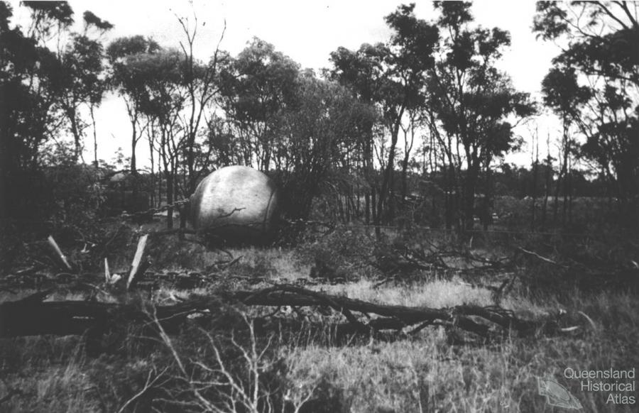
Brigalow (Acacia harpophylla) is a distinctive black-trunked, silver foliaged, shrub or tree - one of the 980 species of Acacia in Australia. Brigalow is found west of the Great Dividing Range, stretching north almost to Townsville, south to Narrabri in New South Wales, west to Bourke on the Darling River and Blackall in central western Queensland. It occurs mostly on deep cracking clay soils with a microrelief pattern referred to as ‘gilgais or melon holes’ which intermittently fill with water. Brigalow is an Aboriginal name adopted by white settlers who pushed north and inland from the Hunter Valley in the 1830s and 1840s. One of the first references to Brigalow was in Ludwig Leichhardt’s journal of his expedition from Moreton Bay to Port Essington, published in 1847.
Early settlement
The early European settlers of the Darling Downs faced a multitude of challenges in transforming the land. During the 1860s and 1870s, as people initially attempted to clear forests for pasture and agriculture, they cursed the dense Brigalow scrubs which defied the axe, fencing them off as waste country. They quickly realised the ability of Brigalow to reappear as dense sucker regrowth, which was even more difficult to remove. A series of droughts affected much of eastern Australia from the 1880s through to 1902 culminating in the Federation drought of 1901-02, when up to 90% of livestock on some properties died and over the southern Brigalow livestock numbers were halved. Over these difficult times, many selectors of Brigalow country abandoned their land and moved to towns to find work. Attempts at closer settlement during this period failed, and it was recognised in The Land Acts Amendment Act 1927 that the size of agricultural and grazing properties needed to be ‘sufficient to afford a prudent selector a reasonable living area … in average seasons’.
Between the wars
After World War I, development of the southern Brigalow lands progressed slowly, due largely to the resilient nature of the plant and the lack of technology to deal with its defences. Between 1880 and 1934, the southern Brigalow Belt was invaded by prickly pear. One might be pardoned for thinking that in those days the chief carrying capacity of the land was wallabies, death adders, snakes, and dingo packs. With the control of the prickly pear in the early 1930s, development of Brigalow lands began again although efforts were relatively slow due to lack of mechanisation. However, the settlers persevered and by the outbreak of Word War II, large blocks of Brigalow around Goondiwindi, Millmerran, Tara, Dalby and Chinchilla in southern Queensland had been cleared mainly by axe, burning and subsequent ‘flogging’ by sheep. The dominance of the settlers over the resilient Brigalow had begun.
Broad-scale clearing
Following World War II, technological change increased the pace of Brigalow ‘development’. One famous land clearing contractor, Joh Bjelke-Petersen - later Premier of Queensland from 1968-87, pioneered a technique for quickly clearing scrub by connecting a heavy anchor chain between two bulldozers. In 1946, army tanks and Bren Gun Carriers (left over from the Pacific War) dragging cables or anchor chains were employed to pull Brigalow scrub. Mechanised clearing soon became a common practice and by 1954 the most determined efforts to clear Brigalow forests began. Settlers were delighted at the ease with which Brigalow could now be cleared, as described in Warrigal-Brigalow battlers in Central Queensland in 1984,
Nuttley’s plant rolled in, and set up camp a half mile south and handy to the road. They had finished Jim’s job and he said to Wal, “You’ll be surprised at how much country those ‘nines’ [Caterpillar D9s] get over in a day.” It was quite a convoy; two tractors, a truck for oil and grease, mobile welder, fuel tanker, air compressor, camping and kitchen vans, Toyota, long chain and other odds and ends… ‘All hands and the cook’ turned out to watch the machines work. They were equipped with blade, tree pusher, and canopy for protection from fallen timber. The long chain was attached to the towbars and moved off two or three chains [22 yards] apart. The chain moved in a great semi-circle, behind leaving a swathe of flattened timber. The Norths had never seen this method of clearing before and the spectacle awed them. Wal rode with one of the operators and was elated to see the thick unproductive scrub come down, in the first stage of conversion to pasture land…. Three more full days saw the whole area flattened and the plant moved on…
In the eight years between 1953 and 1961, 1 million ha were cleared at a rate of 120,000 ha per year.
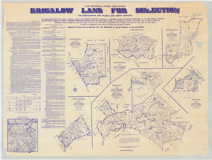
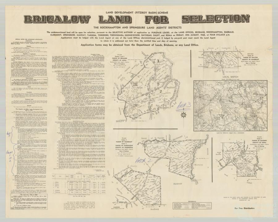
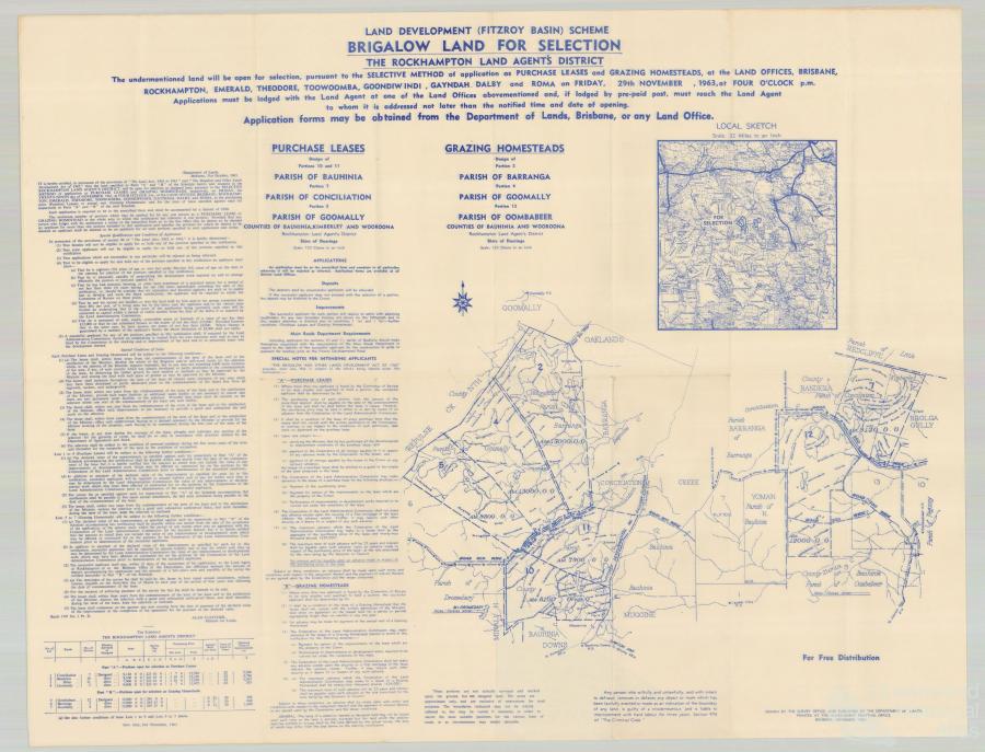
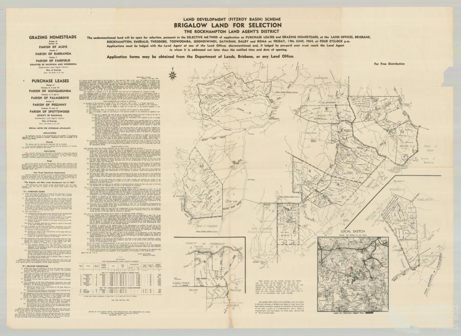
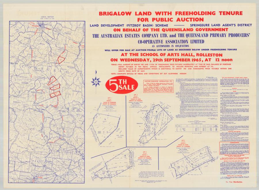
In 1962 The Brigalow and Other Lands Development Act was passed. During the same year, the tree crusher was introduced into Queensland along with the rotary slasher. Under the Brigalow Development Scheme, approximately 2 million ha was allocated in Areas I, IA and II in the Bauhinia, Taroom and Duaringa districts, with a further 2.4 million ha in the Brigalow Belt North. Properties were to be large enough to stock 1000 cattle. State and Commonwealth governments provided loans of up to $60,000 for settlers to cover development costs, plus paying for the construction of 1,200 km of development roads. The Scheme was the first closer settlement policy that provided a combination of infrastructure, adequate financial assistance, and large enough blocks to provide a decent living.
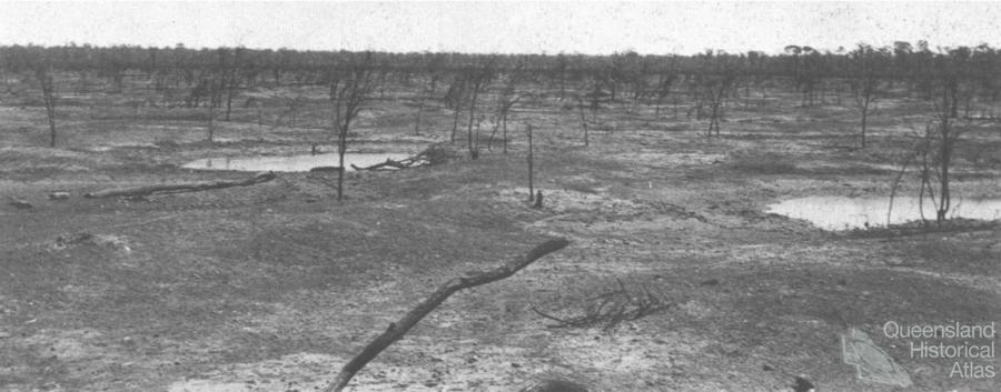
By the 1970s, most of the Brigalow scrub had disappeared. Vast areas of sucker regrowth were controlled by aerial spraying with 245T and 24D, burning and mechanical means, in preparation for improved pastures and cropping. Sheep numbers declined markedly matched by a rise in cattle numbers and the area under crops. The rise in cropping was linked to a severe decline in cattle prices in the 1970s and to the more effective control of Brigalow regrowth using blade ploughing, whereby the roots were cut off under the soil.
The battle to clear the Brigalow had been won. The gain was vast new productive agricultural lands. The loss was a legacy of unforseen environmental problems including the decline of rich biodiversity. Today, Brigalow ecosystems are listed nationally as an endangered ecological community. Linear strips of black-trunked Brigalow line roadsides and paddocks of wheat, sorghum and cattle pastures, standing sentinel to the past. The sheep are almost gone. Regrowth is still a problem to farmers, but governments are now developing policies to ‘Bring Back the Brigalow’.
References and Further reading (Note):
L.M. Seabrook, C.A. McAlpine and R.J. Fensham, ‘Cattle, crops and clearing: regional drivers of landscape change in the Brigalow Belt, Queensland Australia, 1840-2004’, Landscape and urban planning, 78, 2006
References and Further reading (Note):
A. Bailey (ed), The Brigalow Belt of Australia, Brisbane, Royal Society of Queensland, 1984
References and Further reading (Note):
G. McKeon, W. Hall, B. Henry, G. Stone, I. Watson, Pasture degradation and recovery in Australia’s rangelands: learning from history. Queensland Department of Natural Resources, Mines and Energy, 2004
Date created:
22 October 2010 Copyright © Clive McAlpine and Leonie Seabrook
Related:
Transformation